
johnson bayou roads

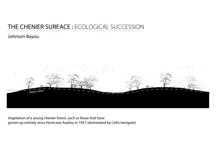
johnson bayou chenier profile

pecan island water bodies

pecan island trees
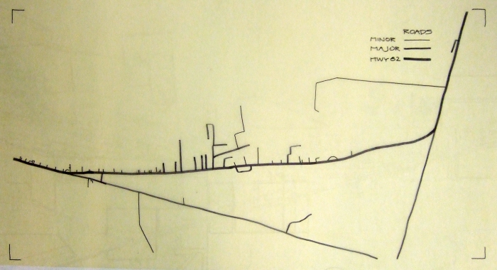
pecan island roads

pecan island structures

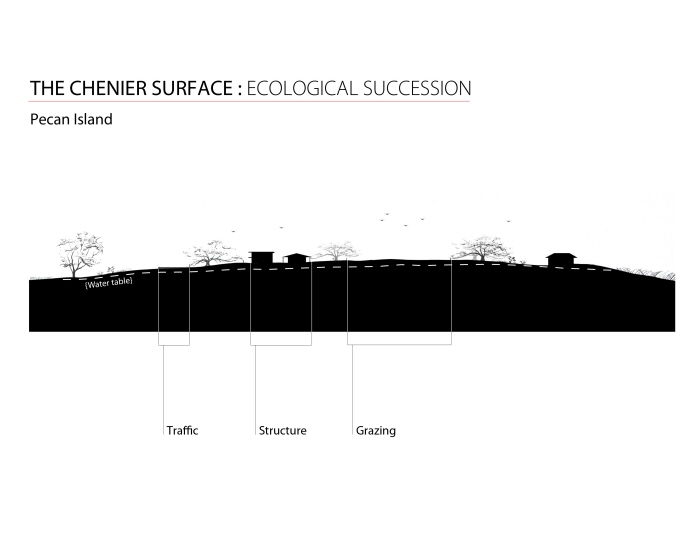
pecan island chenier profile

ELEMENTS : Pecan Island Roads/Structure

ELEMENTS : Johnson Bayou Tree Coverage

ELEMENTS : Johnson Bayou Roads/Structure

ELEMENTS : Johnson Bayou Tree Coverage

SURFACE : Pecan Island Succession (A)
SURFACE : Pecan Island Succession (B)

SURFACE : Johnson Bayou Succession (A)
SURFACE : Johnson Bayou Succession (B)

THEMATIC PLAN : Legend

CONTEXT MAP

THEMATIC PLAN : Pecan Island 1840

THEMATIC PLAN : Johnson Bayou 1982

THEMATIC PLAN : Johnson Bayou 2004

THEMATIC PLAN : Pecan Island 1927

THEMATIC PLAN : Pecan Island 2008

THEMATIC PLAN : Johnson Bayou 1957

MONTAGE 1

MONTAGE 2

MONTAGE 3

MODEL MAP

MODEL MAP

MODEL MAP

Diagram of range of motion in plan view

Diagram of hydraulic pump's increase in force (multiplies 9x)

Diagram of backhoe's complete range of motion

Potential motion of backhoe (plan view), where each joint has rotation in multiple directions

Continuation of potential motion (plan view) with each joint having rotation on multiple axes


LINES/PLANES : Plan view

LINES/PLANES : Perspective

LINES/PLANES

LINES/PLANES

LINES/PLANES


FINAL : boom arm motion - Close-up of motion of joint between boom and stick arms

FINAL : bucket joint motion - Close-up of joint between stick arm and bucket

FINAL : relative joint strengths - Analysis of different strengths of joints, with bucket joint being strongest

FINAL : backhoe range of motion

FINAL : boom range-of-motion

FINAL : hydraulic force

FINAL : varying backhoe sizes - Comparison in scale between typical construction backhoe and the world's largest backhoe, used for dredging.

FINAL : MODEL 1 : Label of parts

FINAL : MODEL 1 : Plan view

FINAL : MODEL 1 : Section view

FINAL : MODEL 1

FINAL : MODEL 1

FINAL : MODEL 1

FINAL : MODEL 1

FINAL : MODEL 2

FINAL : MODEL 2

FINAL : MODEL 2

FINAL : MODEL 2

FINAL : MODEL 3

FINAL : MODEL 3

FINAL : MODEL 3

FINAL : MODEL 3

FINAL : journey [a] dredging

FINAL : journey [b] traversing the land

FINAL : journey [c] replacing chenier

FINAL : arm to ground -- scoop

FINAL : arm to ground -- scrape

FINAL : chenier -- existing

FINAL : chenier -- interfered with

FINAL : chenier -- replaced

FINAL : leg detail

FINAL : building cheniers

FINAL : MODEL 4

FINAL : MODEL 4

FINAL : MODEL 4

FINAL : MODEL 4

project.3 : MASTER PLAN - new plan: has existing dwellings moved to the center of the town of Pecan Island, becoming a cultural and economic center. agricultural land is clustered to the eastern part of site. there are fewer bird-watching trails and no roads with the site

project.3 : PLAN CLOSE-UP (WITH KEY) - plan close up: shows the plan's key. shows the only conglomeration of human activity at the site

project.3 : PLAN CLOSE-UP - plan close up: the northeast corner features some of the farmland that is built to help replace that which is lost due to chenier construction

project.3 : PLAN CLOSE-UP - plan close-up: near the center of the site. highlights the variety of typologies that compliment the cheniers, creating beneficial ecological edges

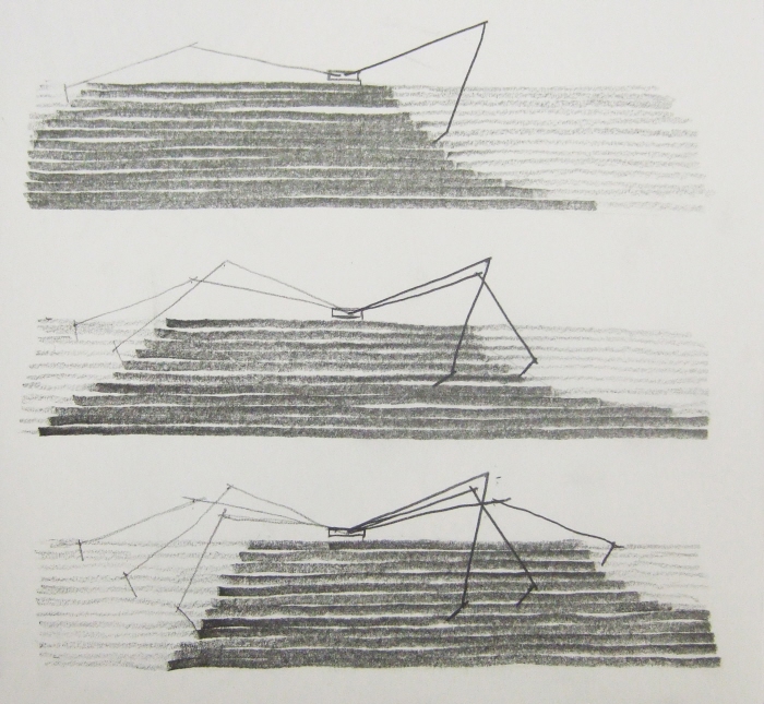
project.3 : AXONOMETRIC--machine process - shows a 4-step process of my machine creating a chenier. set along a linear track (dashed line), it moves up and down within each image, building up land. it moves left to right throughout the axonometric as the land builds up, with the last image showing the completed chenier

project.3 : MACHINE DIAGRAM--forming part of chenier - this is a diagrammatic image of how my machine is in the process of building up land that can become a quality chenier/habitat. the white space is the void that will continue to be filled by the machine and develop into habitat

project.3 : MACHINE DIAGRAM--forming part of chenier - this is a diagrammatic image of how my machine is in the process of building up land that can become a quality chenier/habitat. the white space is the void that will continue to be filled by the machine and develop into habitat

project.3 : PLANTING SCHEDULE - after building the cheniers, the first step is to plant rye grass as an erosion stabilizer and red clover to add nutrients to the soil. smooth cordgrass is planted in the marsh

project.3 : PLANTING SCHEDULE - the second step is to plant large trees on the chenier that grow up and provide quality habitat for migratory songbirds, primarily hackberry and live oak

project.3 : PLANTING SCHEDULE - the final step is to plant the sub canopy and understory plants, which complete the succession and add more quality to the habitat


REVISION : agricultural patterns

REVISION : ecological typologies

REVISION : section A

REVISION : section B

REVISION : section C

REVISION : circulation diagram

REVISION : hydrology diagram

REVISION : structures diagram

REVISION : observation perspective

REVISION : chenier walk perspective

REVISION : marsh walk perspective
gLike
Alex Strader


